Brda –– start
Swornegacie –– you can get there by bus from Chojnice or from Brusy. Charzykowy –– get there by bus from Chojnice.
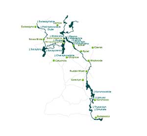
A Detailed Description of the Brda Kayaking Route
A middle section of Brda: Lake Charzykowskie–Gostycyn Nogawica.
- 73,0 km
-
Lake Charzykowskie (area: 1,384 ha, depth: 31 km). A middle section of the Brda river starts in Lake Charzykowskie.
It is possible to set off in Charzykowy, a village that offers vacation lodges and campsites. - 76,0 km
- several original Kashubian farms have been preserved in the Małe Swornegacie village. Brda outflow from Lake Charzykowskie. Go under the bridge, by the headland campsite on the left, towards Lake Długie.
- 78,0 km
- a pass between Lake Długie and Lake Karsińskie, a campsite on the left.
- 80,0 km
- at the northern end of Lake Karsińskie there is the village of Swornegacie. In the centre of the village you will find a neo-baroque church of St. Barbara with Kashubian polychrome, several wooden cottages from the 19th century with roofs covered with straw and a wooden shingle covered chapel..
- 83,0 km
- go under the bridge towards Lake Witoczno. There is a PTTK lakeside hostel. A Zbrzyca river, which is also a picturesque kayaking route, flows into Lake Witoczno.
- 86,0 km
- Brda turns east, go under the bridge and leave Lake Witoczno. The river becomes wide. Go by the campsite in Płęsno and via Lakes Małołąckie and Łąckie.
- 89,0 km
- go by another campsite in Drzewicz, and then under the road bridge on the Swornegacie–Brusy route. You enter Lake Dybrzyk.
- 95,0 km
- Lake Kosobudno –– on the lake the stream is almost imperceptible, at the end of the lake there is a campsite in the forest.
- 97,0 km
- go under the railway bridge and by the village of Męcikał. In the village go under the road from Brusy to Chojnice. Go via Lake Zapora, along the villages of Duża Klonia and Mała Klonia.
- 104,0 km
- Mylof –– a village where the Great Brda Canal starts. There is a hydroelectric power plant, a rainbow trout farming plant and a camping site. Use the trolley to carry the kayaks over the dam (nearly 200 m). The current of Brda becomes faster. Be careful under the bridge due to rapids.
- 110,0 km
-
you reach the village of Rytel, which is a set off point for many kayaking trips. There are several wooden cottages, a post office, some shops and bars. This is where the Great Brda Canal and the river itself fork. Brda, which sometimes becomes very narrow, winds south and creates a small gorge.
You go by several more villages and a camping site in the village of Brda. You enter the Tuchola Natural Landscape Park. - 124,0 km
- go under the road bridge and reach the mouth of Raciąska Struga in the village of Nadolna Karczma.
- 125,0 km
- on the left, a mouth of the Czerska river.
- 131,0 km
- go under the road bridge and reach Woziwoda –– a forest settlement and the seat of the forest inspectorate. There is a campsite and a bus stop. The Brda Valley Reserve starts here. Around 2 km north- west there are two nature reserves –– Lake Kozie and Lake Zdręczono. The current becomes faster and numerous fallen trees make it harder to go through.
- 136,0 km
- a mouth of Bielska Struga.
- 139,0 km
- the Brda is very wide and winding here. On the left, there are two campsites in Gołąbek. The current becomes much faster. Watch out for the rapids.
- 144,0 km
- go under the road bridge on the Tuchola–Tleń route and you reach Tuchola Plaskosz. A bus stop. Go by the railway bridge and the Jagiełło’s Stone –– an erratic boulder.
- 152,0 km
- go under the bridge on the Świecie–Tuchola route in Rudzki Most, which now is a district of Tuchola. There are campsites, OSiR camping lodges and bars. The river gets calmer.
- 155,0 km
- a mouth of the Ruda river. There is a campsite after the road bridge and the Świt forest district.
- 158,0 km
- in Świt the river current becomes faster, the banks are steeper. Watch out for numerous rapids and boulders on your way. Piekiełko –– this section of the river shows a nature of a mountain stream (2‰ grade of water) and is pretty difficult.
- 161,0 km
- you reach a concrete bridge in Piła Młyn. The current gets weaker and you enter Lake Koronowskie.
- 166,0 km
- a PTTK riverside hostel in Gostycyn-Nogawica, a destination of many kayaking trips.
The lower section of the Brda river. Gostycyn-Nogawica –– a mouth of Brda.
- 166,0 km
- Gostycyn-Nogawica. A mouth of Kamionka. A PTTK riverside hostel and a campsite. A hydroelectric power plant in Koronowo and Samociążek. The route leads south via Lake Koronowskie.
- 174,0 km
- a mouth of Krówka. On the left, there is a PTTK riverside hostel in Sokole Kuźnica.
- 176,0 km
- pass the railway bridge and in Sokole Kuźnica go past holiday resorts and then a ferry crossing.
- 184,0 km
- Romanowo (a part of Koronowo) on the right –– shops, a bus station, bars. Go past holiday resorts. On the left bank there is a sailing harbour and a beach in Pieczyska. Go left towards the canal that links Lake Koronowskie with Lake Lipkusz. Go past Koronowo.
- 189,0 km
- there are holiday resorts on the right, go under the bridge in Wilcze Gardło. Next, you reach Lake Białe.
- 196,0 km
-
you reach Samociążek, a holiday resort with campsites, shops, bars and a bus station. You need to carry your kayak along the fence of the hydroelectric power plant (around 200 m). Next, behind the dam, if you go along nearly 5 km upstream, you’ll reach the centre of Koronowo.
Somewhere near Okole the river goes through a valley and you can see meadows and fields. How fast the current is depends on the amount of water that passes through the power plant. - 203,0 km
- the river current gets weaker. You reach the dam reservoir, Lake Tryszczyn. You need to carry your kayak by the dam (80 m). The river current becomes faster. There are shops and a restaurant in Tryszczyn. Go under the bridge in Bożenków-Zdroje.
- 209,0 km
- Bydgoszcz Janowo. A PTTK riverside hostel. Here the Brda river creates two big meanders.
- 211,0 km
- Bydgoszcz Smukała. Go under the bridge. You need to carry your kayak one more time along the power plant on the left. After the power plant the current gets faster.
- 221,0 km
- Bydgoszcz. The trip ends 500 m after the mouth of the Bydgoszcz Canal, which flows into Brda, opposite the kayak pier of the PTTK kayaking club.


 EN
EN 