Choose the language of the site
 EN
EN

-
0,0 km
-
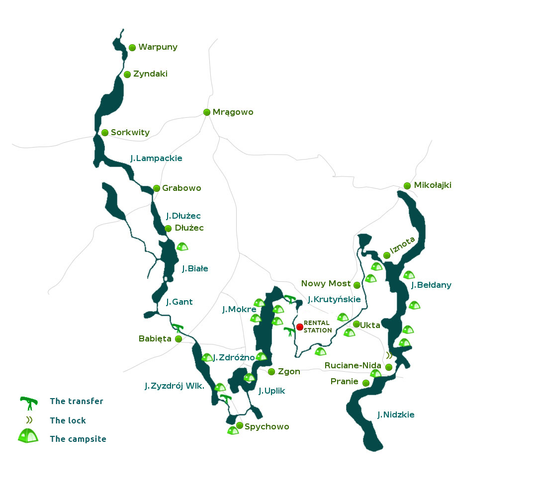
Kayaks are put on water in Zyndaki, on the northern shore of the Zyndackie lake, we get there from Sorkwity. We go south along the right shore. At the end of the lake we go to a stream 1,3 km long
-
1,1 km
-
Under a small road bridge we get to the narrow part of the Gielądzkie Lake (4,76 km2 ,length about 6,9 km, width up to 1,7 km, max. depth 27m,).
-
1,4 km
-
The lake has a nice coastline with many bays and on the shore. In the middle – a big island Ostrów Wielki and some smaller ones with cormorant nests. Eastern (left) shore with forests, on the western – the village Pustniki. Later on the right side the village Gielant. At the end of the lake there is a small and narrow stream, leading under two bridges to the Lampackie lake ( 1,99 km2 , length 3,4 km width up to 1 km, max. depth 38,5 m)..
-
9,0 km
-
On the left the village Sorkwity – with the regional authorities, post office, shops, PTTK campsite.
-
10,5 km
-
On the Lampackie lake we stay on the left and get to the PTTK campsite in Sorkwity. Since 1379 Sorkwity belonged to rich German and Polish families (1750-1804 - Bronikowscy). Since 1804 it belonged to the family von Mirbach. In the years 1850 -1856 this family built a great castle near the lake. On the right shore there is a small peninsula with the remains of the cemetery of von Mirbachs.
-
12,3 km
-
On the left a narrow passage to the Lampasz lake ( 0,76 km2 ,length about4 km, width up to 0,4 km, depth 23 m). It is a long gutter lake with a forest on both sides. On the left sore is the village Jędrychowo.
-
17,0 km
-
At the end of the Lake starts the part of Krutynia called locally Sobiepanka. If the water is low you may have to pull the kayak for 1 km. 200 m further a bridge, a bar and a private campsite.
-
18,5 km
-
Sobiepanka falls into the Kujno lake ( 0,3 km2 , max. depth 5,5 m, length 1,5 km, width up to 320 m). On the left shore there is the village Grabowo, founded 1588. There is a gothic church from the 16th Century here, as well as a bus stop, post office, shops, small health centre.
-
20,0 km
-
At the end of the lake is the beginning of Grabówka – further part of Krutynia with low shores.
-
21,0 km
-
Road bridge on the way Szczytno-Mrągowo. To the right the village Borowe (bus stop)
-
21,5 km
-
Grabówka falls into the Dlużec lake ( 1,23 km2 , length 3,1 km, width up to 0,8 km, max. depth 20 m ). We go along the left shore, there is the village Dłużec.(shop, bus stop)
-
25,1 km
-
At the end of the lake there is a not very long (about 500 m), but hard to find passage to the Białe lake ( 3,59 km2 , length 5 km., width up to 1,5 km, max. depth 31 m). Road bridge on the way. Białe lake has many bays, peninsulas, four islands (you can see and hear cranes here); a great campsite is on the biggest island.
-
27,1 km
-
On the right shore the PTTK campsite Bieńki, camping place with small houses. We go 1 km along the right shore to the river Dąbrówka, among the woods and with deep water.
-
28,3 km
-
Road bridge
-
28,9 km
-
We get to the Gant lake in the woods ( 0,77 km2 , length 2,7 km, width up to 400 m, max. depth 26 m).
-
31,6 km
-
At the end of the lake is the beginning of Babięcka Struga.
-
32,5 km
-
Road bridge.
-
33,0 km
-
On the right – the river Babant ( Tejsy). You go left on Babięcka Struga.
Here you can expand your trail by going against the current of Babant to the Tejsewo lake (length about 1 km), about 700 m. From the lake you go further on a nice river Krawienka. For about 200 m you may have to pull the kayak. But you can really meet wild, not destroyed nature there, so it’s worth it. The only trace of men is a small, destroyed bridge. The distance both ways is 12 km.
From the Tejsowo lake you can also go right on Babant to the lake Babięty Małe ( 0,57 km2 length 2,5 km) about 10 km, and then on the left to Babięty Wielkie ( 2,5 km2 length 5 km, width up to 1,2 km max. depth 65 m). Then on the left you find a campsite. If you go to the other side, to a big bay, you’ll get after about 2 km the end of the stream connecting Babięty Wielkie with the Rańskie lake ( 2,94 km2 length 3,8 km, width up to 1,5 km, depth 8 m), 2 km long. At the beginning of the stream is the village Rańsk (post office, shop, bus). Behind the village you carry the kayaks. After going round the lake we go back to the Krutynia trail. This whole “side excursion” is about 42,5 km long – and you need additional 3-4 days for it.
-
36,2 km
-
Along Babięcka Struga we get to the campsite on the right shore, in Babięta (meals, camping place). 1 km behind the campsite there is a mill, a road bridge and a dam. On both shores the village Babięta. We get to the left shore before the bridge and carry the kayaks for about 80 m. Further the river gets faster, you have to be careful when the water is low.
-
40,2 km
-
Babięcka Struga falls into the lake Zyzdrój Wielki ( 2,11 km2 length4,2 km., width up to 0,8 km, depth up to 14 m), with high shores. On the right shore – the village Zyzdrojowa Wola, on the left shore - Nowy Zyzdrój (holiday centres, shop, bar).
-
42,7 km
-
In the middle of the lake there is a nice sandy peninsula – nice place for a short rest. On the left shore – a camping place. In the middle – a sandy island (camping place).
-
44,3 km
-
The lake becomes narrow. On the left a camping place. Through a narrow passage we get to the Zyzdrój Mały lake ( 0,51 km2). On the left a big peninsula, behind it a non-used sluice Lalka. We carry the kayaks on the right side for about 80 m. The next part of the river is called Spychowska Struga. On both sides swamps with nests of swans and cranes.
-
49,0 km
-
The left shore becomes dryer. At the river a big pier of the PTTK campsite in Spychowo. 1 km further the village Spychowo (in the village there is a shop, small health centre, post office, train, bus). Behind the campsite the river falls into the Spychowskie lake ( 0,5 km2 ). It goes further just a bit later on the left.
-
50,0 km
-
Road bridge on the road Rozogi-Mrągowo. At the bridge the beginning of a 30 m long piece with a very strong current (watch the stones when the water is low!). You have to be careful, it is best to maintain distance of 15 - 20 m between the kayaks and paddle strongly when you leave the bridge area.
-
52,0 km
-
On the right you go (about 0,5 km) to the Kierwik lake ( 0,6 km2 , length 1,5 km). On the left shore of the lake there is a nice place for a rest and a swim, but camping is not allowed!
-
55,5 km
-
Spychowska Struga falls into the Zdrużno lake ( 2,51 km2 length3 km., width up to 1,5 km, depth up to 26 m). Woods on both shores. On the left two big peninsulas and the village Połom. We go along the right shore and after about 600 m we go into a narrowing bay leading to the road bridge in the village Koczek. Behind the bridge Uplik lake ( 0,61 km2 length2,6 km., width up to 0,5 km), a real pearl on the Krutynia trail, with lovely, high shores and many different plants and animals. On the right shore in the middle part of the lake there is the bird reserve place Czaplisko Ławny Lasek with the area of 6,9 hectares.
-
59,5 km
-
Road bridge on the northern end of the Uplik lake. Behind the bridge we get to the big Mokre lake ( 8,46 km2 ,length about 7,7 km, width up to 1,6 km, depth 51 m). There are 5 islands on the lake (together 5 hectares). Along the right shore we have about 1 km to the campsite in Zgon. A holiday village; shop, inn, many private pensions and gastronomy points. Behind Zgon we go along the right shore.
-
62,0 km
-
On the right, opposite to the second island, the nature reserve Królewska Sosna with the area of 103,7 hectares and many great trees (oaks and pines).
-
65,0 km
-
On the right shore a headland, behind it a camping place. On the left in the middle of the lake two big islands. 500 m east from the lake another nature reserve "Zakręt" with about 100-years-old pines and 200-years-old oaks.
-
68,0 km
-
About 1 km before the end of the lake we turn right into a bay. At the end of the bay a dam between the lakes Mokre and Krutyńskie. We carry the kayaks about 25 m on the right shore. Krutyńskie lake ( 0,55 km2 , length about2 km, width up to 0,5 km, depth 3 m,) is in the nature reserve "Krutynia" ( 273 hectares), just as some parts of the river and the forests nearby. The shores of the lake are very interesting, as nothing is changed by men.
-
71,0 km
-
The beginning of the most interesting and beautiful part of the river. Krutynia is fast and wide here; the bottom is sandy, there are many small sandy islands. In summer you can see the boats of “Krutynia gondoliers” here, bringing the tourists to the Krutyńskie lake and back..
-
73,0 km
-
Village Krutyń, founded about 1500 as a hunters’ settlement. Private pensions, restaurants, bars, holiday centres, PTTK campsite. In the village there are some houses from the 19th Century. The seasonal post office is in a barn from the 19th Century. BASE OF THE AS –TOUR COMPANY Krutyń 4
-
75,5 km
-
Village Krutyński Piecek. Road bridge, on the bridge a water mill from the beginning of the 20th Century. You carry the kayaks about 150m on the right shore; you can also rent a cart. Behind the mill the current is quite strong and the water shallow. Watch the rocks in the water.
-
78,5 km
-
Road bridge, village Rosocha.
-
82,0 km
-
On the right side the beginning of a short stream connecting Krutynia and the lake Duś ( 0,42 km2, length about 0,8 km ). On the left shore an old orthodox monastery in Wojnowo. Wooden buildings from 1847. 1996 there were still two nuns here.
-
83,0 km
-
Wooden road bridge. On the right shore village Wojnowo. In the village a wooden orthodox church from 1922 -27 .
-
86,0 km
-
A big village Ukta. Road bridge on the road Ruciane-Mrągowo; ahead of it on the right a private camping place. In 1754 glassworks were opened here. In the village there is a church from 1845.
-
87,0 km
-
On kilometre behind the bridge on the right a PTTK campsite with a camping place. Between the campsite and the Malinowskie lake Krutynia goes through two nature reserves.
-
93,0 km
-
Road bridge, 300 m further the PTTK campsite Nowy Most. Camping place, camping cottages.
-
96,5 km
-
Gardyńskie lake ( 0,83 km2 ,length about1,3 km, width up to 0,9 km, depth11,5 m) with many water plants and looking like a meadow. We turn right and through a small channel we get to the Malinowskie (Malinówko) lake. We stay close to the left shore and get to the narrow Jerzewko lake.
-
100,5 km
-
The lake goes into the last part of Krutynia called Iznota or Czarna Rzeka.
-
101,0 km
-
Road bridge in the village Iznota.
-
101,7 km
-
Krutynia falls into the bay of Bełdany lake ( 9,44 km2 ,length about12,4 km, width up to 1,5 km, depth 46 m). Many islands. A sailing trail goes along the lake. In the north the Bełdany lake is connected to the Mikołajskie and Śniardwy lake. We go south along the right shore.
-
103,5 km
-
On the right shore behind the second peninsula a PTTK campsite in Kamień. Camping place, cottages, gastronomy. We go south along the lake.
-
105,0 km
-
On the right the village Kamień and a big peninsula.
-
106,5 km
-
On the right shore, opposite to the island, camping place.
-
108,5 km
-
On the right the big Wygryńska Bay, there a camping place and the village Wygryny. Houses from the end of the 19th Century, shop, bar. On the left shore village Piaski. On the left we leave the Piaseczna Island. 0,5 km before the end of the lake we turn left.
-
111,0 km
-
Yacht port and the sluice Guzianka, road bridge. On the right the beginning of the town Ruciane-Nida. We get through the sluice (level difference 1,5 m) to the Guzianka Mała lake ( 0,42 km2 , depth 13,3 m). From there to the right, to the Guzianka Wielka lake ( 0,72 km2 , depth 29 m). We stay on the right side and go through a narrow part of the lake and the Nidzki Channel, this way we get to the beautiful Nidzkie lake. At the south-western end of Guzianka Wielka, there is a private haven where you can end your rally (you have to pay for the landing). On the other side a camping place.
-
115,0 km
-
Behind a road and railway bridge the Nidzkie lake ( 18,31 km2, length about23 km, width up to 3,8 km, depth 24 m), with its islands it is a landscape park. We go along the lake, staying close to the right shore. After about 1,5 km we get to the PTTK campsite in Ruciane – Nida, on the right shore at the river Wigrynia. About 2 km to the town centre, trains and buses.
-
116,5 km
-
We end the rally at the campsite.
- Lampackie lake - Krutyńskie lake (Krutynia from 102 km to 45 km) – according to the difficulty scale: t1a which means very easy, even for the beginners. A beautiful trail with very slow currents and without obstacles.
- Krutynia from 45 km to 15,5 km - t1b: easy, even for the beginners. A beautiful trail with mild turns and slow currents.
- Bełdany lake, from 15,5 km - t1: easy, even for the beginners. A beautiful trail with slow currents, without or with few sailing boats and ships.