EN
EN 

Starting point The village Supienie, at the end of the village near the road Filipów - Czarne (city bus from Suwałki), between the lakes: Czarne (Filipowskie) and Rospuda Filipowska. The kayaks are put down to water on the right, before the bridge – it’s also our campsite.
The trail length is 68 km, you need 5 days for it. You can make the rally about 3 days longer if you go on the trail of the river Blizna.
As Rospuda flows through two different regions with different looks: Suwalski Lake District, formed by glaciers, and the flat Augustowski Forest, the trail varies in character – from an almost mountain river with high shores and stones in the water, to slow lowland river with swamp on both sides. The average fall of the river, between the lakes Rospuda Filipowska and Rospuda Augustowska is 0,94 %, and at some places even 3,5 %, which is much for a lowland river. The obstacles, such as stony shallow places with fast current or trees in the water are something negative for some people, but they make this trail even more attractive for the others.
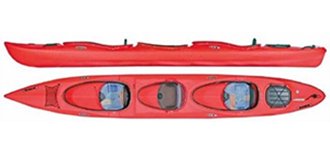
Generally one could say that if you are experienced in kayaking, the rally will be interesting for you. You can make it in a kayak full of equipment in 3-4 days, staying overnight on nice camping places. The trail has a big advantage – you can make it longer by going on the river Blizna, on which you need two days to get to Ateny at the Blizno lake; from there you bring the kayak to Bryzgiel at the Wigry lake, and from that place you can go to the Czarna Hańcza trail and Augustowski Channel to Augustów. It gives you the possibility of getting to know the whole regions of Pojezierze Suwalskie and Puszcza Augustowska during one rally.
Detailed Rospuda trail description.
- 65,0 km
- SUPIENIE, at the end of the village near the road Filipów-Czarne (bus from Suwałki), on the passage between the lakes: Czarne (Filipowskie) and Rospuda Filipowska. A good place for putting the kayaks on water is on the right side before the road bridge, near a nice bay (a good camping place). We are at the beginning of the lake Rospuda Filipowska, called also Jemieliste (3,44 km2, length 5,8 km, width up to 700 m, depth up to 39 m). It is the third biggest (after Wigry and Szelment) lake of the region of Suwałki. In the middle of the lake there is a quite big island – a good camping place. Rospuda has very clean, dark green water.
- 59,2 km
- A pass with a bridge, under which you can get to the other side in the kayak or pulling it. Beginning of the Kamienne lake (0,4 km2, length 2,1 km, width up to 150 m, depth up to 20 m), looking like a part of the lake Rospuda.
- 56,5 km
-
FILIPÓW, a little stone bridge on the local road. 500 m to the right a market place. Filipów is a big village, local centre of trade and services. The streets still look like in 1570, when the village was founded. Also the coat of arms of the village – presenting a cancer – comes from that time. In autumn of 1656 there was a great battle between Poles and Swedes here (lost by the Poles) and the place was destroyed.
Filipów lost its city rights 1870, today 1800 people live here. Between the two world wars there were many Jews and Germans here. That’s why Filipów has four cemeteries. It has also: a post office (16-424 Filipów), a bank, shops, small health centre, veterinary clinic, police station, restaurant „Pod Lipką", cafe, bar, petrol station. - 56,1 km
- Filipów, bridge on the road 652 Suwałki-Gołdap, under the bridge strong current, rocks and a pipe on eye height (ATTENTION!). Further on the remains of an old mill and at the end of the village the third bridge.
- 53,6 km
- Długie lake (0,20 km2, length 1,3 km, width up to 200 m, depth up to 5 m). It looks like a narrow gutter with high naked shores. A good place for angling, as the shore sometimes becomes swampy, but you won’t find a place for swimming or camping here.
- 52,3 km
- SZAFRANKI, road bridge, under the bridge some rocks, behind the bridge a camping place. The river used to be regulated here, so you have to be careful, as there are still some posts in the water.
- 50,7 km
- ZUSNO, paved ford, camping place.
- 49,4 km
- MATŁAK, bridge on the road Bakałarzewo-Filipów, under it a dangerous passage. In the village the oldest in this region traces of people from the Stone Age have been found (from 9500 – 6000 years ago.).
- 49,2 km
- Garbaś lake (1,52 km2, length 3,5 km, width up to 600 m, depth up to 48 m), The shore line is not very interesting, at some places you find woods there. At the bay near the western bank (opposite to the mouth of Rospuda) there is a camping place. Mieruńska Struga (Jaworówka), flowing from Mieruńskie Wielkie lake, with the length of 6,8 km, falls into the lake. The water in the lake is very clean and the bottom sandy, so you can swim everywhere.
- 48,3 km
- You get out of the lake in a shallow place near the road bridge. Further on, a stronger current, leading you through the woods (the fall of water here is up to do 3,5 %).
- 47,8 km
- Głębokie lake (0,12 km2, length 500 m, width up to 200 m, depth up to 17 m), on the northern shore a beautiful forest, on the southern – fields and meadows. There are many water plants here, which makes this lake perfect for the fish. On the eastern bank there is a road in the woods leading to Filipów and through Matłak to Bakałarzewo. 200 m further is the lovely lake Siekierowo, with very clean water and sandy shores – a great place for a swim. Behind Głębokie lake we go through the fields, but there are many obstacles in the water here.
- 45,l km
- BAKAŁARZEWO, a weir of an old, but still working water mill, you have to carry the kayaks for 50 m on the left side. Fro here it’s 200 m left to the market place where you can eat something and go shopping. Lower - a bridge on the road Suwałki-Olecko, behind it in the river concrete blocks. Bakałarzewo is a village with 500 inhabitants (it was a town 1578-1870). The streets still look like in a town, with a big market place and a church in the centre. It was first called Dowspuda Bakałarzewska to distinguish it from Dowspuda Raczkowska. There is a post office, small health centre, youth hostel, bar, shops, pension and private rooms to let here. The church was built of bricks in 1936, it has two towers and inside there is an altar from the 17th Century.
- 44,7 km
- Sumowo lake (l,l km2, length 3,4 km, width up to 350 m, depth up to 13,5 m), a very nice, typical gutter lake, surrounded by nice forests, with many great camping and swimming places. 5 streams flow into the lake on the western side, many springs come out of it on the eastern shore. At the narrow place where you leave the lake there is a small bridge and a good camping place.
- 40,4 km
- KOTOWINA, road bridge, below it shallow stony places (ATTENTION!). Further the river is very calm.
- 38,2 km
- Okrągłe lake (0,4 km2, length 1,1 km, width up to 500 m, depth up to 4,7 m) surrounded by trees, with low banks. There are many kinds of fish in the lake, as well as beavers. The water is green and murky. On the western (right) bank there is a house, the only one left of a former fishing village called Masuria, further, where Rospuda leaves the lake, there is a nice place for a rest and a swim.
- 36,6 km
- Bolesty lake (1,39 km2, length 5,8 km, width up to 250 m, depth up to 15 m), the longest on the trail, looking like a very wide river. It is also one of the most beautiful lakes here. On the northern bank there are some woods, you can find different kinds of berries, nuts and mushrooms there. The southern bank of the lake is steep, many fields are there. A road on the western side connects Kotowina and Raczki and gives access to the lake.
- 30,8 km
- MAŁE RACZKI, village where Rospuda leaves the lake.
- 29,5 km
- Weir of a new water – power station (once a mill), before it a road bridge. You carry the kayaks 100 m on the right shore. Camping place.
- 27,2 km
- Railway bridge, pillars under it. Railway station 1,2 km on the right.
- 26,5 km
- RACZKI, bridge on the road 654 Olecko-Suwałki, rocks under it. A market place where you can eat something is 300 m on the right. It was once a town, now it is a big village with streets looking like a few hundred years ago, it is situated near the historical trade road from Grodno to Prussia. Local trade and services centre, with about 1500 inhabitants. There is: a post office, small health centre, drugstore, police station, restaurant „Rospuda", shops, summer youth hostel here. The village called Dowspuda Raczkowska was founded in the 16th Century. Called Raczki, it got its city rights 1703. 1748 the town was bought by the Pac family and it was a great time for Raczki, especially when Ludwik Michał Pac decided to make this town the centre of his land. The town developed according to the plans of the famous architect Henryk Marconi. Before 1830 there were already 2500 people living here. Unfortunately, the town lost its city rights 1870. In the end of the 19th Century Raczki developed again, because of the trade with Prussia. Also between the two world wars the inhabitants of Raczki lived from the trade with Germany. During the second world war there were three-months-long fights near Rospuda - year 1944/1945 – and the village was destroyed. There is still a valuable building here, a church from the 18th Century, built according to the plans of Piotr Aigner, and rebuilt by Henryk Marconi. There are also some houses from the 19th Century.
- 24,7 km
- DOWSPUDA, a small village near Raczki on the way to Augustów. There are two agriculture schools here, partially in the buildings once belonging to the Pac palace. If you stay on the river, you will recognise this place when you see a slope on the right side, with the so called Stork Tower before a road bridge and a nice camping place. If you climb up the slope you will see the entrance to the palace and the tower – the only remains of the once magnificent building.
- 21,5 km
- CHODORKI, village, bridge on the road Raczki-Augustów. The name of the village comes from the Russian name Fiodor, because first the people from Russia had lived here. A good camping place. Further on the current is fast and there are sometimes broken trees in the water.
- 15,8 km
- „Holy place" with crosses and a chapel, to the left a 300 m long stream to the lake Jałowo, wooden road bridge, camping place. Local people gather in this place on the 24th of June to pray, eat a special meal, bath in Jałówka, put a sacrifice of food and money at the crosses. There is also a 700 years old cross here, making wonders. Jałówka changes its current in spring and brings the water from Rospuda to the lake Jałowo (0,22 km2, length 1,1 km, width up to 350 m, depth up to 12,2 m.
- 12,2 km
- Młyńsko, road bridge. There used to be a big water mill here, it had worked for 400 years, but today there is no trace of it. From here to the mouth the river flows in a valley.
- 8,2 km
- Campsite (Źródełko). The last camping place on the right.
- 4,7 km
- The mouth of Szczeberka on the left side, this river is 48,1 long and flows mostly through swamps. We go against the current and after 2,5 km we get to the road bridge and the mouth of the river Blizna, with which we can get to Ateny or Danowskie at the Tobołowo lake (description further).
- 2,9 km
- Rospuda Augustowska lake (1,1 km2, length 2,6 km, width up to 500 m, depth up to 10,5 m). Ahead of us the island „Wianek", and on the left side the peninsula „Goła Zośka" with a once popular camping place.
- 0,0 km
- Ahead of us the island „Wianek", and on the left side the peninsula „Goła Zośka" with a once popular camping place at the Bar "Gola Zoska" End.
Blizna
- 0,0 km
- 60,3 km from the beginning of the kayak trail of Rospuda, 1,8 km from the place where it falls into the lake Rospuda Augustowska is the mouth of the river Szczeberka. We go against its current.
- 2,6 km
- SZCZEBRA, bridge on the road from Augustów to Suwałki, behind it (on the right) the beginning of the river Blizna, which falls into Szczeberka here. In the village on the left the last grocer’s shop on the way to Ateny! The beginning of the village was the iron production in the 16th Century. Then an inn was built near the road from Grodno to Raczki and further to Prussia, not going through Augustów. Szczebra was very destroyed during both world wars. Almost 8000 Poles, Jews and Russians were shot by the Germans in the fields belonging to the village in the years 1941 -1944, there is a special monument here, to mark this biggest place of executions in the region. As we go on, we turn right into a small river with dark water.
- 6 km
- Railway bridge and a camping place. Railway station „Blizna" 100 m to the left. Rocks under the bridge. Behind the bridge on the right a stream leading to the lake Długie (Kalejty), it is forbidden to go to the lake, as it is environmentally protected. Ahead of us a road bridge and a forester’s lodge, marking the beginning of the long village STRĘKOWIZNA, on the left side. There had been small ironworks here since 1665. You go through the village for a very long time, because the river turns here all the time, and at some places it is so narrow, that it is easier to use the paddles to push the kayak along the shore than to paddle normally. On the way there are some small bridges and a weir where you have to carry the kayaks for 20 m..
- 10,0 km
- At the end of the village on the left a nice camping place near the forest and the bridge on the road connecting Przewieź and Nowinka (you pay the farmer for your stay on it). It is a good place for a rest, because it is not easy to pass Blizna in just one day. Before us is the most difficult – but also most beautiful – part of the trail, where you only go through the woods. Behind the last bridge you can see traces of beavers everywhere. There are many trees and branches in the water, so you have to pull or carry the kayaks many times. At some places there is so little water that everyone has to get out and pull the kayaks and you only can stand it because the place is so beautiful.
- 13,0 km
- Road bridge and on the right side a nice place in the woods, the so called Uroczysko Powstańce, a part of a walking trail from Augustów through Danowskie to Bryzgiel at the Wigry lake. In April 1863 there was a insurgents’ camp here, now there is a plate to commemorate it here – and a nice place for a rest. From here it’s about 5 km more of the river looking similarly to what we have seen.
- 17,5 km
- Bridge on the road leading to the forest settlement UPUSTEK, you see its buildings on the right side./dd>
- 18,2 km
- Blizno lake (2,41 km2, length 5 km, width up to 700 m, depth up to 26 m). You can find many camping places here, as the shores are dry and there are many bays. One of them is directly to the left from the place where Blizna falls into the lake.
- 18,7 km
- ATENY, village with a shop, at the road between Nowinka and Bryzg at the lake Blizno, opposite to the place where Blizna falls into the lake, here you can find transport for your kayaks to Bryzgiel, 6 km from here. If you want to prolong your rally, you stay on the lake and go on, leaving an island on the right.
- 23,0 km
- DANOWSKIE, a village at the eastern end of the lake. You can get to the shore in the northern bay, near a shop. From here you drive to Bryzgiel 5 km. If you really want, you can try and get to the lakes Blizienko (0,39 km2, length l km, width up to 500 m, depth up to 17,0 m) and Tobołowo (0,87 km2, length 2,8 km, width up to 500 m, depth up to 9,5 m), but it is not easy without a flood.